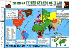
The long-lost "United States of Islam" map
In Who Killed Daniel Pearl (Melville House, 2003), Bernard-Henri Levy makes reference to a map of "The United States of Islam" depicting in one corner an Islamist vision of the world in 20 years (page 421). I've been searching for this map ever since reading the book, and now Little Green Footballs has recovered it from the Web Wastebin with the help of The Internet Archive's Wayback Machine (which has a long memory for potentially embarrassing pre-9/11 sites). Admiration and thanks to LGF. Here's a link to LGF's post.
LittleGreenFootballs: The United States of Islam
I'm not certain that it is the same map HBL had in hand. There seem to be some differences. I suppose we also cannot be certain that the map is not the clumsy work of Mossad or Karl Rove, as the tinfoil-helmet contingent will undoubtedly claim. Nevertheless, here it is.


0 Comments:
Post a Comment
<< Home